
Lincoln’s Trails Keep Growing
by Judy Shutts
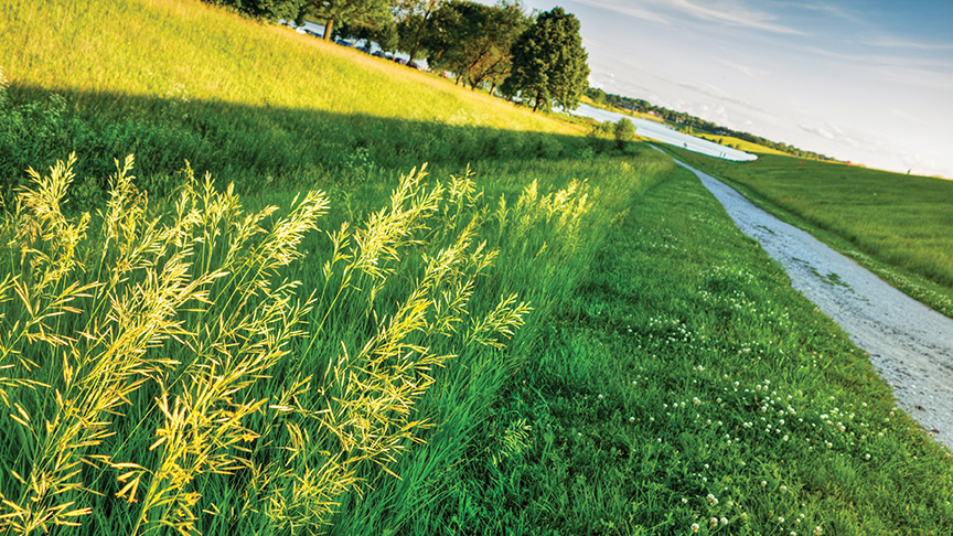
Ready for some outdoor fun? Then lace up your sneakers or hop on your bike and enjoy the more than 130 miles of Lincoln’s multi-use trails.
Lincoln’s trails wind through the corners of Lincoln to the heart of downtown. Runners, walkers and cyclists can connect with places, friends and nature. The trails connect many of Lincoln’s parks, gardens, schools, colleges and universities, swimming pools, and major ballparks. The trails lead to popular destinations such as Lincoln’s Children’s Zoo, the Pinnacle Bank Arena, and the Pioneers Park Nature Center.
The trails are not new to Lincoln; its first trail was constructed in 1978. But with the work of the Great Plains Trail Network, the city’s trails have flourished. Sara Hartzell, Lincoln Parks and Recreation planner, said the Great Plains Trail Network was one of the first groups to come together with the purpose of focusing on trail development. Their advocacy and fundraising efforts helped increase the number of cyclists as well as related groups, businesses and bike events.
And the trail system continues to grow. A 1.4 mile segment was completed on Yankee Hill Road to connect 70th to 91st and the new Moore Middle School. That area includes the new Copple YMCA and Jensen Park south of the school, which is intended for open space and sports fields.
The Cavett Connector Trail connects Tierra/Williamsburg Trail at San Mateo Dr. travels by Cavett Elementary School and then joins Yankee Hill Trail near 34th and Yankee Hill road.
Hartzell said updates include the Boosalis trail along Nebraska 2 that passes the Department of Roads building. The whole length is a 10-foot wide concrete trail. And a heavily-used section of the Billy Wolff Trail on the north side of the dam at Holmes Lake is being completely replaced. The trail will be extended to 10 feet wide.
One of the best-known trails is the MoPac Trail, which stretches 27 miles from the University of Nebraska-Lincoln to the small town of Wabash east of the city. The MoPac was built on an abandoned Missouri Pacific Railroad corridor. It offers a mix of urban and rural settings as winds through the city and extends east into the countryside.
Jerry Mullinix knows the trail well, and the strip from 84th St. to Walton is his favorite ride. “It’s a little more rugged, and you ride through prairies and cornfields,” he said.
Mullinix has jogged or bicycled the trails for 30 years. “When I turned 40, I decided to ride 100 miles in one day.” He accomplished that goal and has jogged and bicycled on the trails since then. He has followed the trails by the Lincoln Children’s Zoo to Highway 2 and then downtown. He used to bike to work and ride home on the Billy Wolff Trail. “I like the old railroad trails because they are slight grades.”
The more you ride, the better it gets. That’s because as more people use the trails, the city wins more grant money. Multiple trail projects around the city are possible because of grant money. For example the new Jamaica and Rock Island trail connection is largely from grants.
The Recreational Trails Program (RTP) is funded by the Federal Highway Administration (FHWA) and administered by the Nebraska Game and Parks Commission. The program requires the applicants to provide a 20 percent match.
And the Great Plains Trails Network has raised millions of dollars toward enhancements of the trails.
The downtown N Street bike lane was also partially funded by grants. Hartzell said the N Street bike lane has been a good thing for Lincoln. Bicyclists can get all the way from any part of town on the bike trails and N Street all the way to the Haymarket, without having to worry about car traffic.
Even though it’s estimated that there are more than one million treks on the trails, each year, the City Parks & Recreation Department is implementing some new technology to get an accurate count. Four more trail counters are being installed that will count the number of walkers, joggers and cyclists. The trail counters are designed on a pole with in infrared beam that counts the users. In the concrete there are diamond-shaped cuts with induction loops that detect metal. They are used to count bicycles only and separate those numbers out from the total people who use the trails. Another counter is mobile on a 2’x18″ cart that can be chained to a sign or a tree.
The trail counters are funded by the Great Plains Trails Network and the Partnership for a Healthy Lincoln. They will provide data that is used for designing trails and roads.
Another incentive to “get out and ride Lincoln” is Bike Share. Bike Share is a system for renting bike for use when sightseeing or exercising. Visitors can rent the bikes at 17 kiosks in downtown and near university campuses. Users can pay with credit or debit cards, or through a smartphone app that allows for a cash option.
According to the American Planning Association’s Public Spaces, Lincoln is considered one of the top 10 biking cities in the Midwest. Approximately 94 percent of Lincoln residents have access to a trail within one mile of their home.
Mullinix said the trails in Lincoln are better than the ones in many cities where he’s traveled. “And the people are friendly.”
The trails attract visitors from out of town, especially for the annual Lincoln Marathon. “The trails are getting noticed,” Hartzell said. “People actually put their bikes in their trucks and drive to Nebraska to ride on the trails.
Visitors and new Lincoln residents can find more information about the trails and/or biking by visiting these websites:
The Great Plains Trails Network at www.gptn.org for maps and more information.
The City of Lincoln at www.Lincoln.ne.gov. Type in “bike” in the search box.

Recent Comments